A remarkable sky.
A shared responsibility.
The North West Highlands still has something increasingly rare: a landscape where natural darkness is part of everyday life. Together, we can help keep it that way.
What is a Dark Sky Reserve?
For the past 24 months, a survey of night skies across the North West Highlands has been examining how dark our skies are and identifying places where that darkness is particularly special. The findings reinforce something many local people already know: we have an extraordinary natural asset above us.
Across much of the region, we can still experience a naturally dark night sky — an experience increasingly difficult to find elsewhere.
A Dark Sky Reserve is an internationally recognised area where the quality of the night sky and the natural night-time environment are valued and protected. We are exploring an application to DarkSky International, the organisation that recognises dark sky places around the world.
The proposal brings together a core with outstanding dark skies and a surrounding periphery, where responsible lighting helps protect that darkness.
Four maps. One landscape.
See the proposed area, its wider setting and two different views of artificial light. Select a map to read its story.
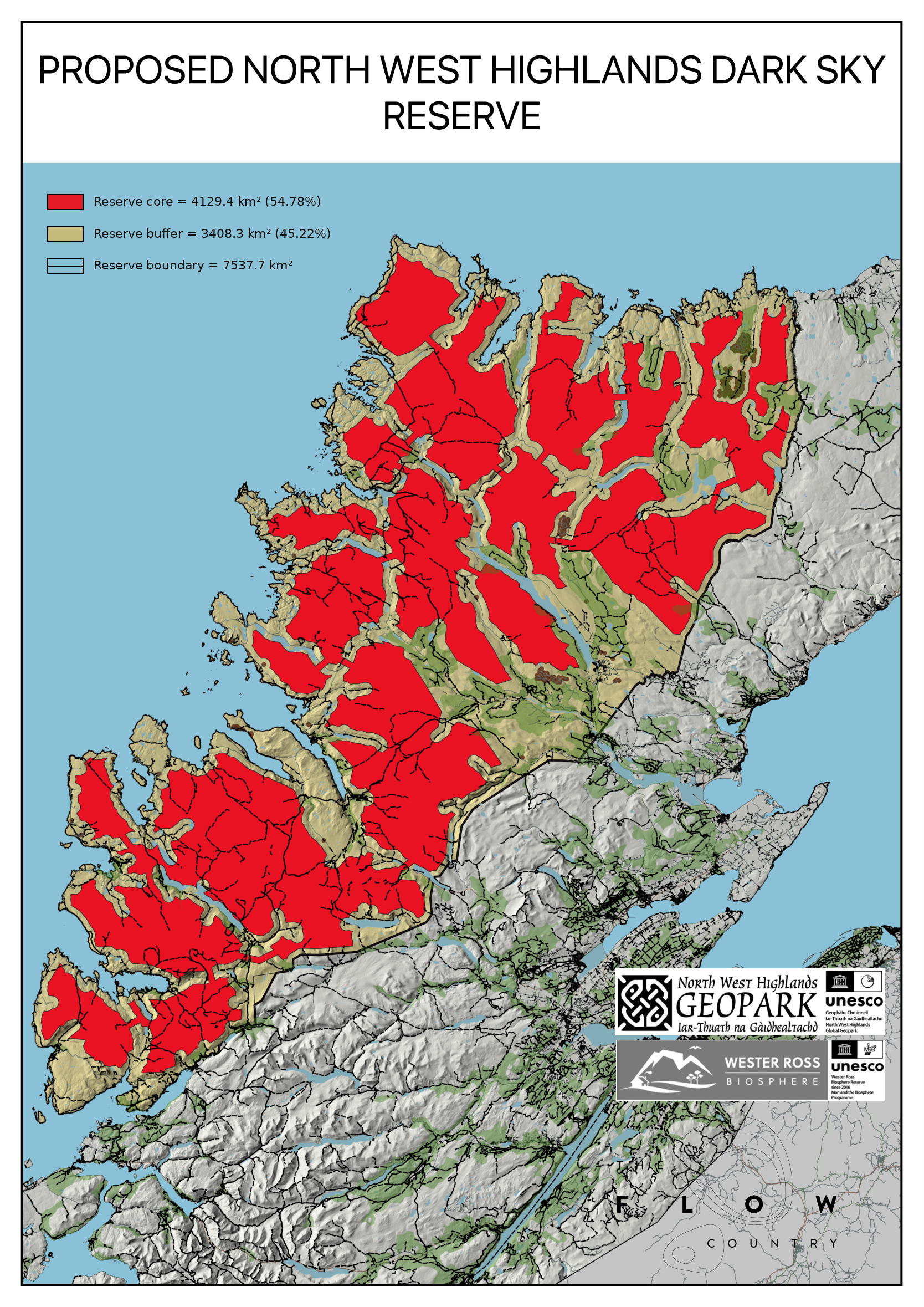
Darkness at landscape scale
This map shows the area currently being explored for the North West Highlands Dark Sky Reserve. Red marks the proposed Core — the landscapes where exceptionally dark conditions are to be protected — while tan marks the surrounding periphery.
The proposed Reserve covers 7,537.7 square kilometres. Within it, the proposed Core extends over 4,129.4 square kilometres, with a further 3,408.3 square kilometres in the periphery. The core accounts for 54.78% of the Reserve and the periphery for 45.22%.
We are looking at darkness at landscape scale. The proposal brings together a large area of mountains, glens, moorland, peatland, coastal landscapes and communities.
The core is not a simple block. Its shape reflects the geography of the North West Highlands and the relationship between remote landscapes, settlements and transport corridors. The surrounding periphery is equally important: lighting choices beyond the Core can influence the quality of the sky within it.
A Reserve therefore needs both outstanding darkness at its heart and a wider partnership committed to looking after that darkness over time. People living and working in the periphery are part of that partnership.
The boundary and zoning shown here are proposals for discussion and assessment. Their detailed configuration must meet the certification requirements. The scale reflects the remarkable extent of the dark landscape we still have.
What the four maps tell us together
The first map shows the Reserve’s proposed scale and structure. The second places it alongside internationally recognised landscapes. The third shows the broad extent of low modelled artificial sky brightness. The fourth shows how relatively localised satellite-detected light remains across much of the area.
Together, they explain why the North West Highlands offers an opportunity for a landscape-scale Dark Sky Reserve. We have an extensive dark landscape, a setting already valued for its natural heritage, and communities that can help protect it through practical decisions.
The maps are complementary evidence, rather than interchangeable measurements. They provide a starting point for consultation, current ground surveys and assessment of the proposal.
The shared message: recognise the darkness we already have and look after it before it is lost.
A vast landscape. Small communities.
The proposed Reserve covers more than three per cent of the UK’s total area, yet is home to less than two hundredths of one per cent of its population. This combination of scale and low population density helps explain the extent of natural darkness — and why local communities have such an important role in looking after it.
Resident count: project’s 2024 census GIS data. Area comparison: 7,537.7 km² ÷ UK total area of 244,376 km². Population comparison: 12,000 ÷ ONS mid-2024 UK population of 69,256,300 (revised October 2026). Density uses the proposed overall area. Percentages and density are rounded.
UK area reference · ONS population reference
How the Reserve and Core Zone were defined
A GIS-based assessment has been used to identify a large, coherent dark landscape while recognising communities, transport, development and practical public access.
Two boundaries, with different purposes
The work was undertaken at two levels. An overall Reserve boundary encompasses the wider landscape proposed for designation. Within it, a more selectively defined Core Zone focuses on the darkest and least developed areas, separating them from roads, buildings and likely artificial-light sources as far as practicable.
Defining the overall Reserve
The proposed area extends from Loch Carron at its southern limit to the north coast around Melvich Bay and Halladale. The western and northern sides make extensive use of the natural coastline, with appropriate offshore islands included where they form part of the wider dark landscape.
The inland boundary was digitised with reference to recognisable landscape features. Rivers and watercourses, catchments, watersheds, ridges and topography were considered alongside settlement patterns, existing land designations and other identifiable features. This produces a geographical boundary rather than one based solely on a fixed radius or administrative unit.
The assessment used Ordnance Survey mapping and terrain information, roads, buildings, settlements, surface water, contours, woodland and place names. Environmental reference layers included Sites of Special Scientific Interest, Special Areas of Conservation, Special Protection Areas, Ramsar sites, National Nature Reserves, Wild Land Areas and National Scenic Areas.
The relationship with The Flow Country World Heritage Site, Wester Ross Biosphere and North West Highlands Geopark, all UNESCO sites, was also considered.
Identifying the Core Zone
The core was developed separately and assessed against more restrictive criteria. Its purpose is to focus protection on extensive areas of natural darkness, paying particular attention to roads, buildings, settlements and associated artificial-light sources.
A GIS setback approach separates the principal core from developed and regularly trafficked areas. An approximately one-kilometre setback from roads and developed corridors provides separation from places where permanent or intermittent lighting is most likely to occur.
Many road corridors and concentrations of buildings therefore remain in the wider Reserve rather than becoming part of the main core, even where the surrounding landscape is very dark. These areas still have a role in responsible lighting and protection of the night-time environment.
This distinction matters in the Highlands, where roads and inhabited glens penetrate remote country. Including every road corridor would overstate the Core’s separation from light sources; dividing it wherever a road occurs would fragment an otherwise extensive dark landscape.
Connecting the dark landscape
A limited number of connecting core corridors were incorporated to maintain continuity between major areas of dark landscape. Their alignments were examined against roads, buildings, terrain and other mapped features, and selected to minimise exposure to development and artificial lighting.
Corridor centre-lines were defined in the GIS and buffered by 500 metres on each side, giving a corridor approximately one kilometre wide. This corridor width is distinct from the approximately one-kilometre setback used around roads in the principal core.
Where possible, the corridors run through undeveloped terrain and away from buildings. Some cross or incorporate short sections of road to connect substantial dark areas. Their inclusion recognises the continuity of the surrounding landscape; it does not imply that the road itself is free of light or traffic.
The connections were reviewed iteratively. Less suitable alignments could be removed and alternatives assessed, so that the proposed Core reflects landscape conditions as well as the GIS analysis.
Buildings and transport routes
Mapped buildings were checked within and near the Core because they may represent existing light sources or locations where future lighting could affect sky quality. Individual structures need to be assessed rather than assuming that apparently remote land is entirely undeveloped.
National, regional and local roads were considered separately, allowing major transport routes to be distinguished from minor roads and tracks.
The core is intended to be overwhelmingly characterised by remote, undeveloped dark landscape. It is not a claim that no roads, buildings or artificial lights occur anywhere within it. Buildings should be considered according to their use, access and lighting characteristics.
67 mapped buildings within the proposed Core
The project’s GIS assessment identifies 67 buildings within the proposed Core Zone. These remote shelters are characteristic of the Highland landscape and should be distinguished from permanently occupied houses, commercial premises and other buildings likely to produce regular artificial light.
Bothies are generally simple shelters reached on foot, commonly without conventional road access, mains electricity or permanent external lighting. Some may be reached by estate or ATV tracks. Their presence does not have the same lighting implications as an inhabited settlement or illuminated roadside property; individual access and lighting arrangements still need to be checked.
Bothies also provide established destinations and shelter in remote country, allowing people to spend time within dark landscapes without requiring new permanent accommodation or lighting infrastructure.
Paths and practical access into the Core
The main recognised paths and long-distance trails within the Reserve have been mapped as part of the assessment. They demonstrate an existing network through which walkers can reach well into the Core, without needing additional roads or major access infrastructure.
In many locations, the approximately one-kilometre road setback places the Core within roughly a 15-minute walk of suitable access points, including recognised walkers’ car parks, for reasonably mobile visitors on suitable terrain. Actual time varies with the route, gradient, surface, weather and darkness; this is not a guarantee for every location or visitor.
The design balances separation from development with the ability to experience the dark landscape without always undertaking a major expedition. The mapped paths can also help identify places for future guided walks, interpretation and observing opportunities.
Access for people with limited mobility
Carefully selected road-accessible core connections have an additional benefit. They may allow people who cannot negotiate remote mountain paths, particularly after dark, to experience the Core landscape and its night sky.
These connections were chosen as far from settlements, concentrations of buildings and other development as practicable. The aim is to retain selected opportunities for access without a substantial walk over difficult terrain, while preserving the predominantly remote character of the Core.
A road-accessible area is not automatically a wheelchair-accessible observing site. Nearby buildings, lighting, traffic, stopping places, parking and surface conditions need individual assessment before particular locations are recommended for accessible observation.
The maps are not navigation guides. Specific routes, observing places and access arrangements require local confirmation, clear guidance and consideration of homes, working land, safety and sensitive habitats.
Wind turbines and the proposed Core Zone
Wind turbine locations and development status were included in the GIS assessment used to refine the proposed Core Zone. A one-kilometre buffer was applied around all turbines recorded as constructed or under construction, and these buffered areas were excluded from the Core.
The project’s current GIS assessment identifies 200 constructed or under-construction turbines within the wider proposed Reserve, with none within the revised Core Zone. This distinction reflects the intention to focus the Core on predominantly undeveloped dark landscapes while recognising existing infrastructure within the wider Reserve. The one-kilometre buffer is a boundary-selection measure; it does not imply that lighting effects necessarily stop at that distance.
The assessment also identifies a further 451 turbine records at various stages of approval, planning or preliminary assessment within the Reserve, some of which fall within the proposed Core. These proposals are considered separately from existing and under-construction turbines, because their planning status, layouts and eventual delivery may change.
Where aviation warning lighting is required, we would encourage developers and the relevant authorities to consider Aircraft Detection Lighting Systems (ADLS), where technically suitable and consistent with applicable aviation requirements. These systems allow warning lights to remain off when aircraft are absent from the relevant detection area, activating them when needed for aviation safety. Required testing and fail-safe operation can also cause the lights to illuminate.
The aim is to support constructive discussion about renewable energy, aviation safety and protection of the natural night-time environment. Proposed developments within or near the Core will require individual assessment, including their potential lighting effects and any implications for the proposed boundary.
Turbine counts: project GIS assessment, October 2026. Aviation lighting guidance: CAA CAP 764: Policy and Guidelines on Wind Turbines.
Core Zone: verified development and lighting inventory
The revised Core Zone measures 4,129.4 km². GIS mapping identifies 67 buildings within it, none with a direct road connection. Their remote locations suggest many may be bothies or shelters, but building uses and residential status have not yet been individually verified.
An intersection of the revised Core boundary with Highland Council’s supplied street-lighting inventory returned zero recorded Council street-lighting assets. This is not a complete inventory of privately operated, agricultural, commercial or other lighting and does not establish that every part of the Core is free of artificial light.
The Core contains no constructed or under-construction wind turbines in the project’s mapped turbine dataset. Future turbine proposals would be considered under applicable planning and aviation safety requirements. The proposed Lighting Management Plan would seek to avoid unnecessary permanent obstruction lighting and, where aviation lighting is required, favour approved aircraft detection lighting systems (ADLS) or equivalent controls where feasible and authorised. ADLS is a proposed policy direction, not a current statutory requirement.
Existing landscape designations and planning controls
The latest GIS intersections show that 4,126.97 km² (99.94%) of the Core overlaps one or more of eight mapped environmental and landscape designation categories. Within this, 2,760.05 km² (66.84%) overlaps the six statutory and associated conservation designation categories considered in the project; 1,682.63 km² (40.75%) lies within four National Scenic Areas. These figures overlap and must not be added together. The eight-category total includes non-statutory designations and does not mean that 99.94% has legal protection specifically for darkness.
National Scenic Areas and conservation sites already benefit from statutory planning or conservation controls, but these are not equivalent to a universally applicable Article 4 Direction, nor do they automatically make a dark-sky Lighting Management Plan enforceable. The project will explore with Highland Council how an adopted lighting policy, relevant planning controls and agreements with lighting and land-management authorities could provide consistent, enforceable management across the proposed Reserve. Existing light sources, private installations and development not subject to planning consent may need separate measures.
The Core’s limited mapped development makes a preventative Lighting Management Plan a realistic objective: maintaining existing darkness and addressing future proposals, rather than undertaking extensive retrofitting of Council streetlights within the Core. Public outreach would be focused on suitable accessible observing locations, avoiding unnecessary pressure on sensitive habitats.
Checking the proposal against night-time light data
The boundaries were considered alongside independent night-time light datasets. VIIRS annual radiance data show the distribution of upward light detected by satellite. The World Atlas of Artificial Night Sky Brightness, published by Falchi and colleagues in 2016 and labelled World Atlas 2015 on the supplied map, models artificial zenith sky brightness at ground level.
These datasets complement each other. VIIRS records light detected from above; the World Atlas estimates its contribution to the sky seen from the ground. Together with settlement, building and transport mapping, they help assess whether the proposed Core corresponds to the darkest parts of the Reserve.
The overall design principle
The approach seeks to achieve four connected objectives:
- Protect the darkest landscapes.
- Minimise exposure to settlements, buildings and significant transport-related lighting.
- Maintain practical pedestrian access through established paths.
- Provide selected opportunities for people with limited mobility to experience the Core.
The wider Reserve contains communities, roads and inhabited landscapes; the Core focuses more selectively on remote dark areas, with existing paths, bothies and carefully considered connections. Its purpose is a dark landscape that can be protected, experienced and enjoyed.
The current proposed areas remain 7,537.7 km² overall, including 4,129.4 km² of core (54.78%) and 3,408.3 km² of periphery (45.22%). The boundaries are an evidence-led proposal, capable of refinement through field assessment, consultation, lighting inventories and direct sky-quality measurements.
Why is this worth doing?
Darkness is part of the natural heritage of the North West Highlands. We already have this remarkable asset; the proposal is an opportunity to recognise it and help ensure that we do not gradually lose it.
Part of our natural heritage
Our landscape is recognised internationally for geology, wildlife, peatlands and scenery. The North West Highlands Geopark, Wester Ross Biosphere and The Flow Country World Heritage Site celebrate different aspects of that environment.
The natural night sky belongs alongside them. The purpose is to value the night-time landscape that is already here and protect its quality over the long term.
Wildlife needs the night
Artificial light at night can affect insects, birds, bats and other animals whose behaviour depends on natural cycles of daylight and darkness. Reducing unnecessary light therefore fits alongside the conservation work already happening across the region.
Darkness is part of a habitat. Sensible lighting can help reduce disturbance beyond the area that actually needs illumination.
Natural darkness and healthy rhythms
Our internal body clock — our circadian rhythm — responds to the daily pattern of light and darkness. Light exposure at night can affect that rhythm and sleep; its effects depend on brightness, timing, duration and the light reaching our eyes.
Valuing dark nights is part of recognising a healthy daily light cycle. The direct health effects of typical outdoor light pollution remain an area of research, so designation should not be presented as a medical intervention.
Tranquillity, wonder and wellbeing
Experiencing a dark sky can offer a sense of tranquillity, wonder and connection with nature. In a region where the landscape is central to people’s sense of place, the night-time landscape deserves to be valued alongside the scenery we see during the day.
Opportunity for our communities
Autumn and winter bring long nights and opportunities to experience the sky at a time when accommodation, cafés, restaurants and other businesses may have spare capacity.
Locally developed activities could include guided stargazing, astronomy events, photography workshops, aurora watching, talks and school activities — or simply a reason for visitors to stay another night and experience the landscape after dark.
These opportunities can grow from existing facilities and local expertise. They do not automatically require large attractions or major infrastructure, and any development should consider community priorities and visitor pressure.
Learning from our own communities
The night sky belongs to everybody. You do not need specialist knowledge or expensive equipment to go outside and begin looking upwards.
Schools and young people can explore astronomy, science, nature, culture and the environment close to home. Community observations through the NELM survey can turn that curiosity into a practical contribution to the project.
Looking back through time
The light reaching our eyes has travelled across enormous distances. Some objects visible to the unaided eye are millions of light-years away: their light began its journey long before humans existed. A dark sky gives us a view into that distant past.
The sky also changes. Stars vary in brightness, and rare events such as novae or supernovae can transform what observers see. Future generations will look out into a universe that continues to evolve.
The night sky is a changing view into a living universe, as well as part of our own landscape.
Further reading: wildlife and ecosystems · natural darkness and human wellbeing.
“Keeping the North West Highlands a place where darkness itself remains part of the landscape.”
How is designation gained?
Dark skies are the starting point. Recognition also needs practical commitments to protect them.
Develop the partnership
Work with communities, landowners and public bodies; discuss boundaries and establish support.
Build the evidence
Document sky quality, lighting and opportunities for people to experience the night sky.
Agree a plan
Prepare a lighting management plan, education activities and long-term stewardship commitments.
Apply and be assessed
Confirm eligibility with DarkSky International, then prepare the application for review. Approval is not automatic.
Keep looking after it
Continue monitoring, outreach and reporting after certification.
Process overview: DarkSky International’s certification guidance. The local timetable and arrangements will need to be agreed as the proposal develops.
Your skies. Your knowledge.
Your reserve to help shape.
Protecting dark skies should be something we do with communities. Local questions, ideas and observations all matter.
Help shape the proposal
This cannot simply be a designation imposed on a map. The communities within the proposed Reserve need to understand it, question it and help shape it.
We want to hear concerns as well as ideas. Local knowledge can help determine what is practical, and how schools, tourism businesses, estates and local organisations might benefit from or participate in the project.
Questions about lighting, costs, access and everyday life are part of that discussion. Consultation should help build a proposal that communities can understand and take ownership of through their involvement.
Residents, community groups, schools, estates and businesses can help decide what is practical and valuable locally.
- Tell us what useful lighting your community needs.
- Share concerns about costs, access, safety or visitor pressure.
- Suggest accessible places for observing and learning.
- Explore school projects, local events and winter business opportunities.
Participation means helping influence the project and its priorities. It does not change ownership of land.
Local meeting dates and a contact route will be added here when confirmed.
Become a citizen scientist
A simple smartphone app has been developed for the survey. NELM means Naked Eye Limiting Magnitude: how faint a star you can see with your own eyes.
By counting stars in the constellation shown in the app, you can contribute an observation of the sky where you are.
- Choose a clear, dark night and a safe observing spot.
- Give your eyes time to adjust; keep screen brightness low.
- Find the constellation shown and follow the app’s star-count instructions.
- Enter your count and submit the requested observing details.
Observations across the region can complement instrument measurements. Repeated observations, made under comparable conditions, can help track change over time. Moonlight, clouds and eyesight can affect a count.
Contribute to the NELM survey with your own eyes and a smartphone.
Keep it handy on your phone. Open the survey in your phone’s browser and use its menu to add the app to your home screen for repeat observations. The option may be called “Add to Home Screen” or “Install app”, depending on your phone and browser.
Long-Term Night Sky Monitoring and Data Collection
The North West Highlands Dark Sky Survey app has been developed to support a structured, long-term programme of night-sky monitoring across the proposed North West Highlands Dark Sky Reserve. Each submission is recorded with a unique observation identifier, date and time, precise geographical coordinates and associated Naked Eye Limiting Magnitude (NELM) and Sky Assessment Method (SAM) readings.
The collected data can be exported in CSV format and imported into our Geographic Information System (QGIS), allowing individual observations to be mapped, analysed and compared across the Reserve and its proposed Core Zone.
By building a cumulative, location-based record of observations over successive months and years, the survey will provide valuable longitudinal evidence of night-sky conditions, help identify potential changes in sky quality and support the assessment of light-pollution trends.
This ongoing monitoring capability is an essential component of the Reserve’s future management and conservation strategy, providing a sustainable, evidence-led approach to evaluating the effectiveness of dark-sky protection measures.
The app also encourages public participation in citizen science, enabling residents and visitors to contribute directly to the long-term protection of the North West Highlands’ exceptional night skies.
The survey is intended to allow participation without providing your name. Each submission records precise geographical coordinates as well as its observation details. Check the app’s privacy information for how location and any technical data are stored, used and displayed before you submit.
What would designation mean for everyday life?
The proposed Reserve is about protecting a natural asset while supporting the people who live and work here. The emphasis is on awareness, practical improvements and good lighting decisions, especially when a light is replaced or a new one installed.
Existing lighting does not become illegal simply because Dark Sky status is awarded. Any lighting commitments, timelines and local policies needed for certification should be explained clearly as the plan develops.
People need appropriate lighting around homes, roads, paths, businesses and community facilities. Reducing glare and unnecessary spill can help put useful light where it actually serves a purpose. Better design can improve visibility and reduce wasted electricity, while limiting disturbance to neighbours and wildlife.
Small changes can protect a big sky.
When you install or replace an outdoor light, a few questions can help you get the light you need with less waste.
Useful
What does this light need to illuminate?
Directed
Can it point downwards and be shielded?
Appropriate
Could a less bright light do the job?
Controlled
Would a timer or sensor suit its purpose?
Warm
Could a warmer-coloured light meet the need?
Appropriate lighting remains essential for homes, paths, workplaces and community facilities. Good design should consider visibility, access and safety as well as the surrounding environment.
What would it mean for me?
Clear answers matter. Some details depend on the lighting plan and local agreements that still need to be developed.
Will I have to change the lights on my house?
Designation itself does not make your existing light illegal. However, certification requires a lighting plan and improvement commitments. What applies locally, to whom and over what period must be explained through consultation. The proposal focuses on practical improvements and good practice, with any specific requirements explained as the plan develops.
Will this introduce new planning restrictions?
DarkSky certification carries no legal or regulatory authority of its own. Existing processes remain relevant; any locally proposed policies or agreements need separate explanation.
Does this mean we cannot have street lighting?
No. The aim is appropriate lighting where it is needed, designed to reduce glare and unnecessary spill. Roads, paths and public facilities must be considered in the local lighting plan.
Will businesses have to switch their lights off?
The proposal is about useful, well-designed lighting. Businesses need safe working environments. Brightness, direction and operating times can be considered together; any specific commitments should be discussed with the businesses concerned.
Is this just for astronomers?
No. It is also about landscape, nature, education, wellbeing, energy and local opportunity. Enjoying the night sky requires neither specialist knowledge nor expensive equipment.
Why seek designation if our skies are already dark?
Because we have the chance to look after an asset before it is lost. Recognition can help bring people together around a shared, lasting commitment.
Are the boundaries final?
No. These maps show the proposed geographical approach. Boundaries and the arrangement of Core and Periphery areas need community discussion and assessment against DarkSky’s requirements.
Does the reserve change land ownership or access?
The proposal does not mean community ownership of the land. Observers should use appropriate access routes, respect homes and working land, and follow local guidance. Public night-time access arrangements form part of the application.
Can I contribute without a telescope?
Yes. The NELM survey uses your own eyes and a smartphone. You can also contribute local knowledge, help organise activities or discuss practical lighting choices.
Can I take part anonymously?
The survey is intended to accept observations without your name. Location information may still be needed to make an observation useful. Check the app’s privacy information for exactly what is collected, stored and displayed.